The Great Goat Trail Debate
Bob Wells | Mar 10, 2010

It’s not easy being a City of Boulder Open Space planner. The planning professionals hosted the community Tuesday night, Feb. 9, at Foothill Elementary School on Hawthorne Ave. to discuss a local institution called the Goat Trail.
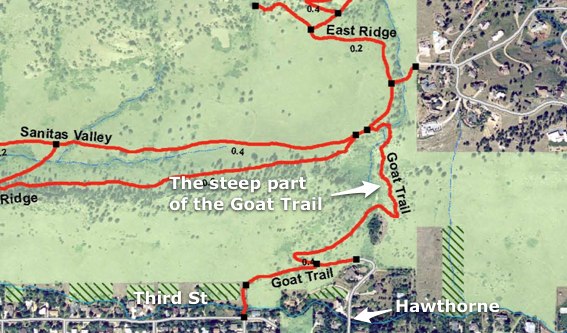
The controversial part of the Goat Trail is a steep run-up from just west of the head of Hawthorne connecting to the Mt. Sanitas trail system over the ridge to the west. It’s steep enough for a goat to love, or it may have got its name from an eccentric lady, Minnie Mae Cunningham, who had a rambling and rundown place, and numerous goats, just south of Linden and bordering the foothills. (She was most famous for driving around town with goats in her car.) Anyhow…
On Tuesday night, the planners were oh so professional and conciliatory and so respectful of the sainted “process” that governmental and nonprofit types worship so. They presented their opinion that the trail was too steep, erosion-prone and dangerous, and offered an option that would substitute an easier path from Hawthorne up and over the ridge.
Crowd demands vote
It didn’t go well for the planners. When it came time for “neighborhood input,” the assembled throng clamored, predictably, that they like the trail the way it is. One warned that a proposed less-steep route would stumble right into what he knew was mountain lion habitat. The crowd — very North Boulder, ranging from 30s to 70s and clad in decidedly unfashionable aging-outdoorperson drab — demanded a vote.
The option obviously favored by the planners, a looping path to the ridge running south of the existing steep trail, garnered, alas, one vote. The big winner was to keep the existing trail as is, with some minor modifications to some of its obviously dicey spots (the worst being a couple of small rock faces that require serious scrambling).
Possible mistake by planners: Those in attendance were not pleased that it was they who had to demand that a vote be held. They wanted to, and got to, go on record, in numbers. Make a note for future planning, planners: attendees not pleased by this aspect of the so-called “process.”
It’s not easy being a planner. You go to lots of trouble to invite a large swath of North Boulder to a meeting. You get your Powerpoints ready and prepare your talk, with all the right process-speak. You serve cookies. And the public hits you with a most resounding: No.
Some analysis
Want my opinion? I’ve lived in this neighborhood and used this trail for close to 30 years. My “noon fitness” group from North Boulder Rec Center used to run up it regularly (we also swam — don’t tell anyone — in Wonderland Lake sometime).
Ya know what? The Goat Trail is so steep and hard-to-navigate that we long ago took to giving it the more dramatic name of Suicide Trail. Frankly, we avoid it, instead opting to get in our car and drive to a couple of trailheads around Mapleton to get to Sanitas (I know, I know, we should be biking to the trailheads).
The planner-proposed less-steep option would actually give a lot of people access to Mt. Sanitas who don’t presently have it because of steepness of the Goat Trail. But it appears the neighbors don’t want the change. In fact, some even hinted darkly that the big motivation for change on the part of planners comes from money that needs to be spent, lest it be lost within a certain tight timeframe. Oooo, bureaucratic conspiracy.
We can’t support the conspiracy theory. It’s just about some well-intentioned and very professional planners being planners, and trying to create a more “sustainable” solution (which, let’s face it, they usually do). Them versus predicably staunch and vociferous fans of the status quo. It’s the kind of thing that makes local politics go round and round. Our hunch is that the status quo (plus some needed work on the existing trail) will probably win this round.
Go try it
An, oh yes, if you haven’t tried the Goat Trail ascent to Mt. Sanitas, do. If you’re in decent shape and have hiking boots, it’s really a piece of cake — the steep part taking maybe all of 10 minutes. A few dicey spots featuring rock-scrambles and steep, loose soil. All in all, gorgeous and a guaranteed heart-rate speedup. Just drive or bike to the head of Hawthorne and start walking. Upward.

